Remotely sensed land cover datasets have been increasingly employed in studies of wildlife habitat use. However, meaningful interpretation of these datasets is dependent on how accurately they estimate habitat features that are important to wildlife. We evaluated the accuracy of the GAP dataset, which is commonly used to classify broad cover categories (e.g., vegetation communities) and LANDFIRE datasets, which classifies narrower cover categories (e.g., plant species) and structural features of vegetation. To evaluate accuracy, we compared classification of cover types and estimates of percent cover and height of sagebrush (Artemisia spp.) derived from GAP and LANDFIRE datasets to field-collected data in winter habitats used by greater sage-grouse (Centrocercus urophasianus). Accuracy was dependent on the type of dataset used as well as the spatial scale (point, 500-m, and 1-km) and biological level (community versus dominant species) investigated. GAP datasets had the highest overall classification accuracy of broad sagebrush cover types (49.8%) compared to LANDFIRE datasets for narrower cover types (39.1% community-level; 31.9% species-level). Percent cover and height were not accurately estimated in the LANDFIRE dataset. Our results suggest that researchers must be cautious when applying GAP or LANDFIRE datasets to classify narrow categories of land cover types or to predict percent cover or height of sagebrush within sagebrush-dominated landscapes. We conclude that ground-truthing is critical for successful application of land cover datasets in landscape-scale evaluations and management planning, particularly when wildlife use relatively rare habitat types compared to what is available.
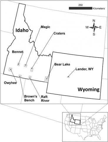
Fig. 1. Greater Sage-grouse (Centrocercus urophasianus) study areas in southern Idaho were visited between 2011 and 2014 in winter. Transects were conducted at patches within each study area to obtain field-collected data on major vegetation types and structural characteristics (percent cover and height) of shrubs.
| GEM3 author(s) | |
| Year published |
2021
|
| Journal |
Journal of Environmental Management
|
| DOI/URL | |
| GEM3 component |
Mapping
|
| Mentions grant |
Yes
|

