Private lands provide key habitat for imperiled species and are core components of function protectected area networks; yet, their incorporation into national and regional conservation planning has been challenging. Identifying locations where private landowners are likely to participate in conservation initiatives can help avoid conflict and clarify trade-offs between ecological benefits and sociopolitical costs. Empirical, spatially explicit assessment of the factors associated with conservation on private land is an emerging tool for identifying future conservation opportunities. However, most data on private land conservation are voluntarily reported and incomplete, which complicates these assessments. We used a novel application of occupancy models to analyze the occurrence of conservation easements on private land. We compared multiple formulations of occupancy models with a logistic regression model to predict the locations of conservation easements based on a spatially explicit social–ecological systems framework. We combined a simulation experiment with a case study of easement data in Idaho and Montana (United States) to illustrate the utility of the occupancy framework for modeling conservation on private land. Occupancy models that explicitly accounted for variation in reporting produced estimates of predictors that were substantially less biased than estimates produced by logistic regression under all simulated conditions. Occupancy models produced estimates for the 6 predictors we evaluated in our case study that were larger in magnitude, but less certain than those produced by logistic regression. These results suggest that occupancy models result in qualitatively different inferences regarding the effects of predictors on conservation easement occurrence than logistic regression and highlight the importance of integrating variable and incomplete reporting of participation in empirical analysis of conservation initiatives. Failure to do so can lead to emphasizing the wrong social, institutional, and environmental factors that enable conservation and underestimating conservation opportunities in landscapes where social norms or institutional constraints inhibit reporting.
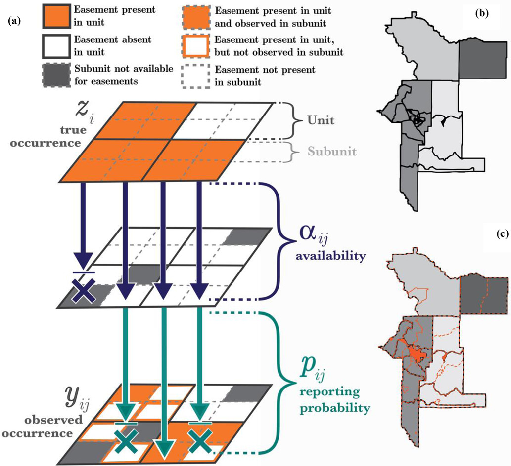
(a) Use of spatial subsampling to determine the probability of easement occurrence (arrows, direction of data-generating process; X, condition where availability [aij] or reporting probability [pij] prevents observation [yij] of an easement that is present). True easement occurrence ![]() in each spatial unit (here, U.S. Census tracts, [c]) is only partially observable. Spatial subunits (here, U.S. Census block groups, orange-dashed lines in [c]) are treated as repeated visits in the occupancy framework, wherein data observed (yij) are a function of the true occupancy state for the tract (zi), the probability that some of the block groups are unavailable for easements (aij), and the probability that an easement is reported by the easement holder (pij).
in each spatial unit (here, U.S. Census tracts, [c]) is only partially observable. Spatial subunits (here, U.S. Census block groups, orange-dashed lines in [c]) are treated as repeated visits in the occupancy framework, wherein data observed (yij) are a function of the true occupancy state for the tract (zi), the probability that some of the block groups are unavailable for easements (aij), and the probability that an easement is reported by the easement holder (pij).
| GEM3 author(s) | |
| Year published |
2020
|
| Journal |
Conservation Biology
|
| DOI/URL | |
| GEM3 component |
Mapping
|
| Mentions grant |
Yes
|