Context The amount and composition of phytochemicals in forage plants influences habitat quality for wild herbivores. However, evaluating forage quality at fine resolutions across broad spatial extents (i.e., foodscapes) is challenging. Unmanned aerial systems (UAS) provide an avenue for bridging this gap in spatial scale. Objectives We evaluated the potential for UAS technology to accurately predict nutritional quality of sagebrush (Artemisia spp.) across landscapes. We mapped seasonal forage quality across two sites in Idaho, USA, with different mixtures of species but similar structural morphotypes of sagebrush. Methods We classified the sagebrush at both study sites using structural features of shrubs with object based image analysis and machine learning and linked this classification to field measurements of phytochemicals to interpolate a foodscape for each phytochemical with regression kriging. We compared finescale landscape patterns of phytochemicals between sites and seasons. Results Classification accuracy for morphotypes was high at both study sites (81–87%). Forage quality was highly variable both within and among sagebrush morphotypes. Coumarins were the most accurately mapped (r2 = 0.57–0.81), whereas monoterpenes were the most variable and least explained. Patches with higher crude protein were larger and more connected in summer than in winter. Conclusions UAS allowed for a rapid collection of imagery for mapping foodscapes based on the phytochemical composition of sagebrush at fine scales but relatively broad extents. However, results suggest that a more advanced sensor (e.g., hyperspectral camera) is needed to map mixed species of sagebrush or to directly measure forage quality.
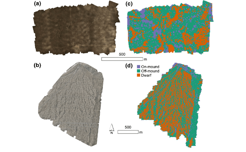
Figure 3. Unmanned aerial system orthomosaics for the (a) Camas and (b) Cedar Gulch study sites in Idaho, USA in summer, and classified maps of sagebrush morphotypes (Artemisia spp.) for the (c) Camas and (d) Cedar Gulch study sites.
Spanish Translation Podcast:
Mapeo del paisaje alimentario de la artemisa usando drones
This podcast was made possible by the NSF Idaho EPSCoR Program and by the National Science Foundation under award number OIA-1757324.
| GEM3 author(s) | |
| Year published |
2020
|
| Journal |
Landscape Ecology
|
| DOI/URL | |
| Mentions grant |
Yes
|